
August 11, 2026 | 12:21 pm

TEMPO.CO, Jakarta - A recent study by researchers at the National Research and Innovation Agency (BRIN) sheds light on what caused the high tsunami waves in Pangandaran, West Java, following the magnitude-7.7 earthquake on July 17, 2006. Several studies show that wave heights topped eight meters in several areas, while survivor testimonies suggest they even exceed the height of local coconut trees.
Wiko Setyonegoro, a researcher at BRIN’s Deep Sea Research Center, noted that the earthquake's epicenter lay along an oceanic megathrust. Therefore, it carried the potential to trigger a devastating tsunami across the Pangandaran and Cilacap coastal regions.
On Pangandaran's western and eastern shores, Wiko added, tsunami heights reached between 8 and 9 meters. "Surges from the west and east coasts met in the Pananjung Sari area, submerging most of the area," he told Tempo on Monday, August 10, 2026.
Dislocations and Ocean Floor Shifts
Wiko and his team calculated the tsunami heights using the Wells and Coppersmith Equation (1994). The results were then compared with the Takemura (1998) formula for assessing tsunami disasters.
Out of several modeling scenarios tested through field investigations, data analysis, and evaluations, a few closely matched the observed dynamics of the 2006 disaster. "The latest simulation points to a secondary source that eluded the early warning system for non-tectonic events," Wiko explained.
The simulations revealed that the quake fractured a rupture zone extending up to 600 kilometers long and 95 kilometers wide at its epicenter, located 200 to 300 kilometers off the hard-hit Pangandaran-Cilacap coastline. The cracks generated structural dislocations that lifted or dropped the seabed by an average of 13 meters.
Wiko added that following the main shock, the ocean floor’s bathymetric structure suffered submarine landslides, deformation, subsidence, and structural collapse. These seabed disturbances displaced vast volumes of seawater, amplifying the resulting tsunami waves. "Based on calculations across several scenarios we conducted, the earthquake's actual energy was equivalent to a magnitude 8.7," he said.
Underwater Landslides
The research team also estimated the tsunami's arrival time assuming underwater mass displacement played a role near Pangandaran Regency. Modeling based strictly on a single seismic event, whether magnitude 7.7 or 8.7, yielded the same result: the tsunami should have taken over 40 minutes to reach shore. However, empirical data from 2006 survivors indicates the waves struck in just 20 to 30 minutes.
"Thus, our hypothesis is that non-tectonic mass movements, such as underwater landslides, likely contributed to the heightened amplitude of the 2006 Pangandaran tsunami," Wiko noted.
Pepen Supendi, a seismologist at the Meteorology, Climatology, and Geophysics Agency (BMKG), noted that the tsunami hit roughly one hour post-quake, between 4:15 p.m. and 4:30 p.m. local time, with wave heights ranging from 5 to 10 meters.
Impact and Casualties of the Disaster
In addition to Pangandaran, the tsunami battered Cilacap and southern Yogyakarta along a 250-kilometer stretch of coastline. Pepen explained that the tectonic rupture was relatively slow over three minutes at a shallow depth as the earthquake and tsunami struck the region.
This slow rupture mechanism meant ground shaking felt on land was relatively mild. Yet, the length of the fault rupture extended across 200 kilometers.
"The reason it caused such a massive tsunami in Pangandaran was that the epicenter was near an oceanic trench, which effectively uplifted the seafloor," Pepen stated during a webinar marking the 20th anniversary of the Pangandaran tsunami on July 16, 2026.
According to the Pangandaran Regency Regional Disaster Management Agency (BPBD), the 2006 tsunami claimed 405 lives, left 27 people missing, injured 274, and displaced 13,198 residents.
Read: Java Megathrust: 20 Years After Pangandaran Tsunami
Click here to get the latest news updates from Tempo on Google News
Java Megathrust: 20 Years After Pangandaran Tsunami
23 hari lalu

The Pangandaran tsunami remains Java's largest since the Banyuwangi disaster, arriving after relatively weak earthquake tremors.
Pangandaran Shaken Once Again by 4.2-Magnitude Earthquake
5 Mei 2026
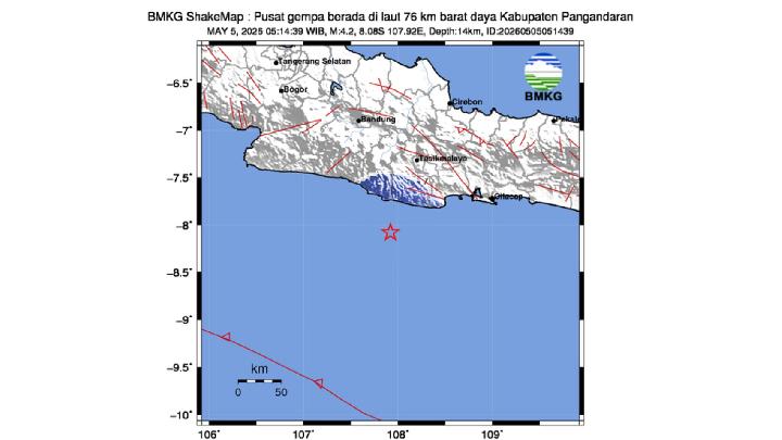
A 4.2-magnitude tectonic earthquake has once again rocked the Pangandaran area and its surroundings in West Java, Indonesia.
M4.0 Earthquake Hits Off Pangandaran, No Damage Reported
4 Mei 2026

A 4.0 magnitude tectonic earthquake struck the southern coast of Pangandaran and its surrounding areas, the BMKG says.
M4.0 Earthquake Hits Off Tasikmalaya Coast, Tremors Felt in West Java
28 April 2026
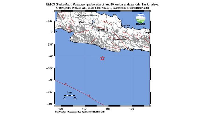
Meteorology, Climatology, & Geophysics Agency (BMKG) says that the earthquake is a type of shallow earthquake due to subduction plate activity
Ex-Minister Demands Prabowo Act on Pangandaran Floating Net Cage Promise
10 Agustus 2025

Former Minister of Maritime Affairs and Fisheries, Susi Pudjiastuti, expressed her concern over the issuance of permits for floating net cages in the East Coast of Pangandaran, West Java.
92 Earthquakes Rock West Java Throughout June 2025
1 Juli 2025

A magnitude 5 earthquake that struck Pangandaran on June 9, 2025, was among the most strongly felt by residents.
High Waves Claim Lives of Three Teenage Tourists on West Java's Coast
4 April 2025

Tourists are prohibited from swimming at the beach due to the high waves ranging from 2 to 3 meters on the south coast.
BMKG: 4.3M Earthquake Jolts Pangandaran, Tremors Felt in Nearby Regions
8 Januari 2025

As of 11:57 a.m., BMKG monitoring has not detected any aftershock activity.
Police Nab Village Honorary Employee in Pangandaran Overseeing 585 Pornographic Websites
14 November 2024

Commissioner Dani Kustoni said 'OS' a.k.a. Anefcinta had managed 585 pornographic websites and uploaded 1,058 pornographic videos.
M4.7 Earthquake Hits Pangandaran; BMKG Detects Tremors Reaching Central Java
25 Maret 2024
The Meteorology, Climatology, and Geophysics Agency (BMKG) recorded a tectonic earthquake with a magnitude of 4.7 near Pangandaran on Sunday night.




























:strip_icc():format(jpeg)/kly-media-production/medias/5220347/original/094913800_1747281277-41961081_8976420.jpg)

:strip_icc():format(jpeg)/kly-media-production/medias/5327298/original/085035000_1756177391-Cek_Fakta_Tidak_Benar_Ini_Link_Pendaftaran__83_.jpg)
:strip_icc():format(jpeg)/kly-media-production/medias/5558454/original/058152900_1776419419-cek_fakta_-_petani_milenial_2026.jpg)


:strip_icc():format(jpeg)/kly-media-production/medias/5534795/original/014528000_1773892938-khutbah.jpg)

:strip_icc():format(jpeg)/kly-media-production/medias/4449837/original/055086300_1685614290-WhatsApp_Image_2023-06-01_at_17.06.22.jpeg)


:strip_icc():format(jpeg)/kly-media-production/medias/4909950/original/090842100_1722854822-WhatsApp_Image_2024-08-05_at_17.40.39_50d920d6.jpg)
:strip_icc():format(jpeg)/kly-media-production/medias/4120045/original/038413400_1660195971-pexels-david-mceachan-87500.jpg)
:strip_icc():format(jpeg)/kly-media-production/medias/5531332/original/004830000_1773565920-bantuan_DAP_australia_umat_kristen.jpg)